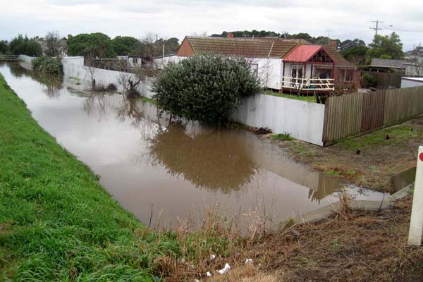
RESIDENTS have begun to evacuate their homes in Koo Wee Rup as rising floodwaters threaten properties.
Residents from 30 homes have already left and a further 30 will be evacuated this morning as the Bunyip River continued to rise.
With more rain predicted, Lang Lang residents were braced for possible evacuations. SES units were being told to report with a boat for emergency response in the Lang Lang area.
Just before 11am VicRoads closed the South Gippsland Highway in both directions between Westernport Road and Caldermeade Road, Lang Lang.
Police said residents unable to make alternative arrangements with friends or relatives, would be able to use facilities at the Cardinia Cultural Centre, which had been setup for relief.
State Emergency Service spokesman Lachlan Quick said a main drain near the river was also flooding, posing a threat to homes. It was not known whether the system was blocked.
Click on the image below for our gallery of the Heatherton Road flooding.

“It looks like it’s not coping with the amount of water that is flowing through there,” he said.
The Moe river was also causing concerns.
Bureau of Meteorology forecaster Peter Newham said the area around Koo Wee Rup could expect further heavy falls of between 10 and 20 millimetres until about 8pm tonight.
He said the region had experienced heavy rainfall in the past 12 to 18 hours. At 8am today, Koo Wee Rup had received 62 millimetres of rain since 9am yesterday.
Click on the image below for our gallery of the Koo Wee Rup and Lang Lang floods.

‘‘There is still rain pushing in around a low-pressure system through that area so it will ease gradually through the afternoon,’’ Mr Newham said.
‘‘There will still be some fairly heavy rain or showers around that area, but not as heavy as it was I believe last night. It looks like probably another 10-20 millimetres over the next 12 hours in that region.’’
Streets affected included Williams Street, Salmon Street, Ti Tree Street, Black Fish Street, Boundary Drain Road and Henry Street.
Emergency services, along with volunteers from the Red Cross have assisted in the evacuation, which began about 3.30am.
Overnight the SES responded to 200 calls for help across the state, including two rescues of people from vehicles stuck in floodwaters.
Police said residents unable to make alternative arrangements with friends or relatives, would be able to use facilities at the Cardinia Cultural Centre, which had been setup for relief.
Melbourne can expect another cold and wet day, although the rain should ease during the afternoon. A top of 12 degrees is forecast today in the city.
‘‘No large rainfall amounts are expected through the weekend [in Melbourne],’’ Mr Newham said.
Motorists were warned to drive to the conditions and be aware of changed conditions. A number of roads around Melbourne have also been closed due to flooding.
VicRoads said all southbound lanes on Lysterfield Road in Ferntree Gully were closed between Napoleon Road and Monbulk Creek due to flooding.
All west-bound lanes on Heatherton Road, from the Monash Freeway at Endeavour Hills To Stud Road in Dandenong, have also been closed due to flooding.
Other road closures include:
* Thompsons Road, from Berwick-Cranbourne Road at Clyde North to William Thwaites Boulevard at Cranbourne East.
* Dandenong-Hastings Road, from Eramosa Road East at Somerville to Bungower Road at Somerville.